Wayfinding: Maps and Resources
A selection of maps featured in the Wayfinding exhibition, courtesy of Adam Apt. Click to enlarge.
-

- AMC, 1887

-

- AMC Hut System Postcard

-

- AMC map of trails, 1947

-

- B&M Bird’s Eye view Mt Washington

-

- B&M RR Map, 1886

-

- Belknap, Map of New Hampshire

-

- Boardman. Map of the White Mountains New Hampshire, 1858

-

- Central New Hampshire

-

- Coast Survey, Moosilauke

-

- Colebrook NH Birds eye view, 1887

-

- Comparative view of the heights of the principal mountains in the world, 1820

-

- Crawford map of White Mountains, Benton McKaye’s copy

-

- Crawford Notch USGS quadrangle, shadedfile0010.tif

-

- Cutter, Northern Presidentials, 1914

-

- deBerard, Map of the AMC Hut System

-

- Durand, plan of circa 1820 e

-

- Farmer and Moore 1823

-

- Flume House envelope map

-

- Flume House envelope

-

- Forest Density of Northern New Hampshire

-

- Guyot, 1860

-

- Hitchcock atlas geology sheet 1

-

- Hitchcock atlas geology sheet 2

-

- Hitchcock atlas geology sheet 3

-

- Hitchcock atlas panoramas sheet 2

-

- Hitchcock atlas panoramas sheet 2

-

- Hitchcock atlas surficial geology sheet 1

-

- Hitchcock atlas surficial geology sheet 1

-

- Interior of Tip_Top House, Mt. Washington

-

- J Rayner Edmands, manuscript survey notes

-

- Leavitt Map of the White Mountains, 1859

-

- Leavitt’s Manuscript Map of the White Mountains, 1877

-

- Leavitt’s Mansucript Map of the White Mountains, 1879

-

- Map of the White Mountains and Lake Wiinnipisogee

-

- The Most Perfect Map Ever Issued , Cover

-

- Most Perfect Map, Bird’s Eye View of the White Mountains

-

- Oliver’s Guide Map to North Conway,

-

- Perspective map of White Mountains, Robbins, 1933

-

- Pickering, Map of the Mt. Washington Range,1882

-

- Pitman, Plan of Mt Washington area

-

- Powder Horn

-

- Powder Horn

-

- Profile of Second Division of the W.M.N.H.R.R Extension.

-

- R.D. Woodard. Pocket relief map. 1930

-

- Ragweed Free Areas in New Hampshire trifold

-

- Ragweed Free Areas in New Hampshire trifold

-

- Robbins, White Mountains
-

- Robbins, White Mountains
-

- Saussure, Alps, Bird’s-Eye View

-

- Schedler’s New Relief Map of the White Mountains

-

- Schedler’s New Relief Map of the White Mountains, Cover

-

- Scarborough’s Topographic Map of the White Mountains, 1903. Courtesy of Dartmouth College Library

-

- Squam Lake, 1858

-

- Tamworth, New Hampshire, 1932

-

- USFS Proclamation, 1918

-

- WMNF, 1918

-

- Walling, 1877

-

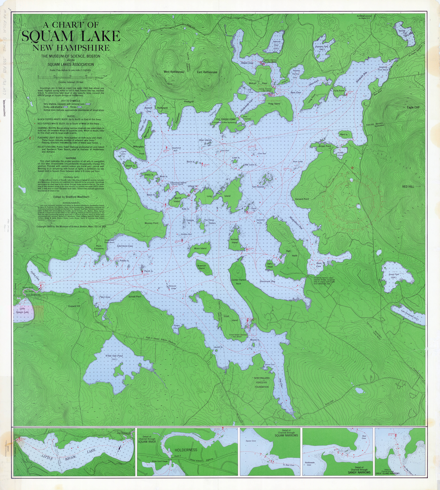
- Washburn’s Chart of Squam Lake, 1969. Courtesy of Dartmouth College Library
-

- Washburn’s Map of Mt. Washington and the Heart of the Presidential Range, 1994

-

- Weetamoo and Piper Trails

-

- White Mountains of New Hampshire. National Geographic, 1937

-

- Wyman, Autumnal Catarrh

Resources
WhiteMountainHistory.org
- The Cartography of the White Mountains, by Adam Jared Apt
- 25 Early White Mountain Maps (high resolution scans)
- Scarce White Mountain Maps (high resolution scans)
- Franklin Leavitt Maps (high resolution scans)
- White Mountain National Forest Maps, by David Govatski (high resolution scans)
- 1805 Town Survey Maps (high resolution scans)
Digitized Map Collections
- Harvard Map Collection
- Dartmouth College Digital Collections: Maps
- Osher Map Library
- US Geological Survey Topographical Maps
Kids Resources
New Hampshire Historical Society Moose on the Loose: Social Studies for Granite State Kids
Suggested Reading
Apt, Adam. Tolerable Accuracy: A History of White Mountain Hiking Maps. Pages 170-197 in White Mountain Guide: A Centennial Retrospective. Edited by Katherine Wroth. AMC Books. Boston. 2007.
Carchedi, David. Scaling the White Mountains. A Selection of White Mountain Maps. Jackson Historical Society. 2014. Jackson, NH.
Cobb, David A. New Hampshire Maps to 1900. An Annotated Checklist. NH Historical Society. Concord, NH. 1981. Pages 198-204
Cottrell, Bob. Toponomy and Topography. White Mountain History Blog. December 18, 2020. http://mwvhistory.blogspot.com/2020/
Garland, Larry. Entering the Digital Era. Pages 198-204 in White Mountain Guide: A Centennial Retrospective. Edited by Katherine Wroth. AMC Books. Boston. 2007.
Mudge, John. Mapping the White Mountains. Durand Press, Etna, NH. 1993.
Remembering Rodney Woodard. The Resuscitator. Spring 2011. OH Association. Newton, MA. https://www.ohcroo.com/wp-content/uploads/2017/08/Spring2011.pdf